Moa Point water sampling map
Following the flooding on 4 February at Moa Point Wastewater Treatment Plant, untreated wastewater has been discharging via the long outfall pipe into Cook Strait.
To monitor water quality along the south coast shoreline while this discharge of untreated wastewater continues, we have increased the number of sampling locations and the frequency of sampling. Wellington Water continues to monitor water quality around the region as part of our stormwater and wastewater management and consent requirements. You can find our regular water sampling results on our Environmental Monitoring page
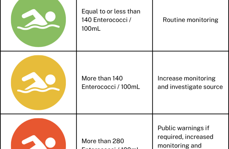
LAWA's trigger levels and corresponding management responses
When water quality falls in the ‘Surveillance’ category, it indicates a low risk of illness from swimming. If water quality moves into the ‘Alert’ category, it indicates an increased risk of illness from swimming, though still within an acceptable range. However, if water quality reaches the ‘Action’ category, it poses an unacceptable health risk from swimming.
Note that under the 2003 guidelines, health warnings for coastal waters are only issued after two consecutive samples (within 24 hours) exceeds the ‘action’ trigger level.
Latest results - 26 to 31 May
- This week’s water sample results show that the majority of sample sites had acceptable levels of bacteria across the week. The high result on 29 May at Dorrie Leslie Boat Ramp has been noted.
- We are continuing to monitor results to understand coastal trends over time.
- Check the map above for the latest water sampling results.
Notes on sample sites
- Since the announcement of the change in public health advice on 25 February, we made changes to the locations and frequencies of water sample sites.
- In our immediate response to the Moa Point incident, we sampled Wellington’s south coast and eastern bays from Mahanga to Ōwhiro Bay daily to build up a picture of the discharge’s impact on water around the south coast and surrounding area.
- Following this frequency of sampling, we found that overall, the water near the shore has been within the acceptable limits for safe swimming in dry weather conditions. Note that:
-
-
- Rainfall affects water quality, even if a site normally has very good weather conditions. LAWA's standard advice is to avoid swimming for 48hrs after rain.
- We are still developing our understanding of what happens during southerly conditions, but strong southerly winds have the potential to push contamination towards the shore.
-
-
- Our current water sampling schedule includes:
-
-
- Sites that are monitored daily because of their proximity to the long and short outfalls.
- Sites that are monitored three times per week because they are useful for continuing to build up a picture of what happens in certain weather conditions.
- Sites that are monitored weekly because they require less frequent oversight but are still important for understanding the situation.
-
-
- The sampling schedule has been designed to ensure we are targeting the right areas around the south coast and to give confidence in the quality of results.
- Regular sampling is also undertaken as part of Greater Wellington’s Recreational Water Quality Programme, and these results can be viewed on the LAWA website.
Latest public health advice
- The public health advice issued on 25 February remains in place. People can return to the beaches and swim near the shore in the area from Ōwhiro Bay to Breaker Bay in good weather conditions where LAWA indicates it is suitable.
- Tarakena Bay remains a no-go area due to its proximity to the short outfall pipe. The warning also remains to not collect kaimoana from Ōwhiro Bay to Breaker Bay.
- There are some areas and environmental conditions can also affect risk. Strong southerly winds may push contamination towards bays and closer to shore.
- The sample sites we have been testing have not included areas out in the Cook Strait near the long outfall pipe, so activities further from the shore such as surfing and diving may carry a higher exposure risk and should be conducted at people’s own risk.
- For further public health advice, including answers to frequently asked questions, please visit Health NZ’s website.
- To check whether it is safe to swim at any of the south coast beaches, please go to LAWA’s website.
Current sampling schedule
|
Daily
|
Fortnightly |
Historical |
| Dorrie Leslie West | Owhiro Bay | Mahanga Bay |
| Dorrie Leslie Boat Ramp | Scorching Bay | Seatoun Beach at Wharf |
| Houghton Bay West | Seatoun Beach at Inglis Street | |
| Lyall Bay at Queens Drive | Princess Bay | |
| Dorrie Leslie Park South | ||
| Te Raekaihau Parking | ||
| Island Bay West | ||
| Hue Te Taka Peninsula West | ||
| Marine Centre | ||
| Moa Point near #49 | ||
| Moa Point short outfall | ||
| Tarakena Bay West | ||
| Tarekena Bay at boat ramp | ||
| Hue Te Taka Peninsula | ||
| Breaker Bay | ||
| Lyall Bay at Onepu Road | ||
| Lyall Bay at Tirangi Road | ||
| Lyall Bay Beach Eastern side |
Additional context
- Moa Point wastewater treatment plant continues to discharge screened, but untreated, wastewater into the environment via the long outfall pipe, and the short outfall, which isn’t screened, is likely to be used during rainfall. In the event the short outfall is used, LAWA remains the best source of information for safe swimming at beaches.
- There is no evidence to suggest the discharge from Moa Point Treatment Plant is reaching the inner harbour.
- The rāhui remains in place for Tarakena Bay.
Public health advice
Can I go on the beach and in the water?
The public should follow LAWA’s advice on whether beaches are suitable for swimming.
Daily sampling along 23 sites along the coast has shown that during dry weather (excluding the days immediately following wet weather) these results have been within the acceptable bacterial levels for safe swimming near the shore.
Some caution is still advised. The sample sites have not included areas out in the Cook Strait near the long outfall pipe, so activities further from the shore such as surfing and diving should be conducted at people’s own risk.
Can I gather kaimoana?
No. People should not collect or eat kaimoana from the affected areas (Ōwhiro Bay to Breaker Bay) at this time.
Kaimoana can become contaminated by sewage. Shellfish such as mussels and pipi carry the highest risk because they filter large amounts of water and can concentrate harmful bugs, which may remain in their tissues for several weeks. Other species such as pāua, kina, crayfish, and fish are generally lower risk but can still be contaminated while sewage discharge is ongoing.
Because sewage discharge is continuing and conditions can change, the safest approach is to avoid collecting or eating any kaimoana from affected areas as a precaution to protect health.
What is LAWA’s standard advice?
LAWA’s standard advice is to not enter the water during rainfall, or after rain for 48 hours. This advice remains in place. The public are strongly urged to check LAWA.org.nz before entering visiting beaches and entering the water.
13 May update
Please see below for water sampling results for 5 to 11 May.
Key points
- While the majority of sample sites had acceptable levels of bacteria across the week, we can see results related to rainfall and the use of the short outfall.
- We are continuing to monitor results to understand coastal trends over time.
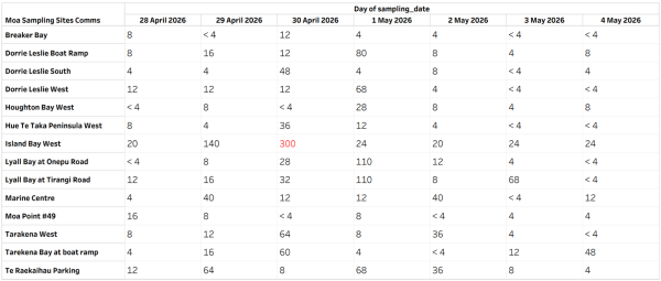
6 May update
Please see below for water sampling results for 28 April to 4 May.
Key points:
- This week’s water sample results show that the majority of sample sites had acceptable levels of bacteria across the week.
- Rain is the likely cause of the high result on 30 April at Island Bay West.
- We are continuing to monitor results to understand coastal trends.